|
|
 |
 |
Crete Info
Geography
Crete lies at the
point where the continents of Europe, Asia and Africa
meet. It is the fifth largest island in the Mediterranean
with an area of 8,335 square kilometers. It has an
elongated shape with an east-west axis and a length
of 257km. The island of Crete flanks the southern
entrance to the Aegean basin and must always have
been a focus for sea - travellers between the coast
fingers of Europe, Asia and Africa. Its widest points
in the centre are about 60km apart and its narrowest
near Ierapetra in the east, only about 12km. Crete
is set in an area which is geologically unstable and
has consequently been affected by frequent earthquakes,
some of which in Bronze Age, account for severe destructions
of palaces and towns. There have been other environmental
changes of a less dramatic kind which have had their
influence throughout the island's long history. For
example, the Mediterranean being virtually tideless,
the evidence of submerged settlements, houses and
harbour installations in many places around its shore
indicates that the level of the sea has risen since
ancient times.
|
|
The geological composition of the
island and the sismic upheavals it has suffered over
the ages have caused it to be honeycombed with many
hundreds of caves and rock - shelters, some of them
small, others vast, not a few of extreme archaeological
and religious importance. In recent times, as so often
in the past, caves have been used by the Cretans as
places of refuge and focal points of survival and resistance.
Many have been associated with the Christian religion;
and even today there are said to be over a hundred churches
in Cretan caves. Roughly two - thirds of the whole surface
of the island consists of the mountainous regions now
so conspicuously rugged and barren; nowadays nearly
half the land area is only suitable for romantic grazing.
|
 |
The island has no navigable rivers, for
the streams which can be called rivers are too swallow and rocky.
Prefectures
and Provinces
Crete is divided into four prefectures (nomos). From
west to east they are: Chania, Rethimnon, Iraklion
and Lassithi. Each one of the prefectures is subdivided
into provinces (eparchies). The Nomos Chanion is subdivided
into Kydonia, Apokoronas, Sfakia, Kissamos and Selino.
The Nomos Rethimnou is subdivided into Rethimnon,
Milopotamos, Amari and Agios Vasilios. The Nomos Irakliou
is subdivided into Malevizi, Temenos, Pediada, Pirgiotisa,
Kainourio, Monofatsi and Vianos. The Nomos Lassithiou
is subdivided into Mirabelo, Lassithi, Ierapetra and
Sitia.
|
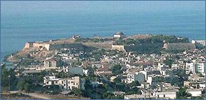
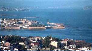
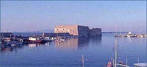
Chania Prefecture
 |
The prefecture (nomos) of Chania
covers the western section of the island. It has an
area of 2,376 square km. Chania is subdivided into five
provinces (eparhies): Kydonia, Kissamos, Apokoronas,
Selino, and Sfakia. The main cities of the prefecture
are Chania, the capital, and Kastelli in Kissamos. The
main towns are Paleochora and Kandanos in Selino, and
Hora Sfakion in Sfakia.
The prefecture of Chania offers a wide variety of tourist
services and activities of all classes and types.
|
|
The city of Chania
has also maintained characteristics of the Venetian
era. The Lefka Ori rise behind Chania and drop to the
Libyan Sea in Sfakia and contain many gorges and canyons
for the nature or hiking enthusiast. The sandy beaches
and clear waters of Falasarna, Paleohora and Georgioupolis
offer pleasant swims. The Minoan, Roman, Byzantine,
Venetian and Turkish archaeological sites attract those
seeking cultural and historical information.
The province of Kissamos in the northwest of the prefecture
of Chania lies between the two peninsulas of western
Crete. It extends west to the sea and south to Elafonisi
Island. Kastelli is the main city of this area. The
city has a variety of tourist services. On the coastal
road from Kastelli to Elafonisi Island you can see the
wild beauty of western Crete. The beaches at Elafonisi,
Falasarna, and Gramvousa are among the finest in Crete.
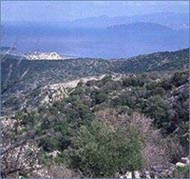
The province of Sfakia occupies the southeast area of
the prefecture of Chania. The Lefka Ori cover most of
the area. Sfakia has the highest peaks of the Lefka
Ori: Pahnes (2,450m); Kastro (2,218m), and Troharis
(2,409m). This wild terrain is one of the most impressive
in Crete. The visitor may enjoy the panoramic view going
from Chania to Sfakia by road. Very impressive also
is the Samaria Gorge excursion and the subsequent boat
trip to Hora Sfakion.
|
Rethymno Prefecture
|
Rethimnon
is one of the four prefectures (nomos) of Crete.
It lies between the prefecture of Iraklion and the prefecture
of Chania, and consists of four provinces (eparhies):
Rethimnon, Milopotamos, Amari, and Agios Vasilios. The
main cities of the Nomos are Rethimnon, Agia Galini,
Anogia, Amari. These two provinces of Rethimnon
and Milopotamos occupy all the area on the north coast
of the prefecture of Rethimnon. The entire area is easily
reached from the city of Rethimnon.
|
|
|
The roads in the
provinces are good, usually paved, but narrow and winding.
The excursions in this area go east and west along the
picturesque Old Road between Rethimnon and Chania and
Rethimnon and Iraklion. The construction of the National
Road isolated these small villages in the 70s but this
adds to their attraction. Hidden among these villages
are Minoan sanctuaries, cemeteries, villas, and palaces.
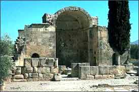
There are many Byzantine churches in the prefecture
of Rethimnon. Some of the later churches have interesting
frescoes such as the Panagia Kardiotissa in Miriokefala.
The church in Moni Arkadiou is one of the finest examples
of Venetian influence on the architecture of the time
and the monastery a symbol of the love of and sacrifice
for freedom. Rethimnon is an area of traditional villages
(Anogia), Byzantine churches, and ancient sites. The
Oropedio Nida, one of the most beautiful and historic
plateaus in Crete, is high in the Psiloritis Mountains.
The Ideon Andron Cave in Nida is reputed to be the birthplace
of Zeus or the place where Zeus was raised, according
to others.
|
Heraklion Prefecture
 |
The prefecture
of Iraklion is the largest in area, has the greatest
population and the highest per capita income of Crete.
There are seven provinces (eparhies) in this prefecture:
Malevizi, Temenos, and Pediada on the north coast and
Pirgiotisa, Kainourio, Monofatsi, and Viannos in the
centre and on the south coast. The main cities are Timbaki,
Ano Viannos, Matala and Mires.
Iraklion is the main city. The valleys of the prefecture
are the largest of grape - producing areas of Crete
and its main products are sultana raisins, Malevizi
(Malmsey) wine, and table grapes (Rosaki).
|
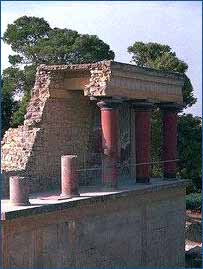
|
In these valleys Sir Arthur
Evans, the British archaeologist, excavated the Minoan Palace
of Knossos the remains of a great civilization.
A low mountain range rises in the middle of the prefecture
and descends into the Mesara Plain. These fertile plains have
been cultivated for thousands of years and have important
Minoan, Greek, and Roman archaeological sites -- Festos, Agia
Triada, and Gortyn are the major ones. The imposing peak of
Psiloritis, 2,456 metres above sea level, is visible from
almost all points of the prefecture of Iraklion. It is especially
impressive during the winter months when it is snow-capped.
The prefecture of Iraklion has many cultural and historical
features to offer the visitor. The finest collection of Minoan
artefacts in the world and the sites of one of history's greatest
civilizations may be of interest as well as the numerous Byzantine
churches and Venetian castles and fountains.
The historical aspects combine with the scenic landscapes
of mountains, valleys, and sea to make this a beautiful and
fascinating area. The beaches of Agia Pelagia and Limin Hersonisou
on the north coast and Matala and Kali Limenes on the south
coast will attract the visitor with their warm, clear seas.
There are many fine restaurants and tavernas offering Cretan
specialities throughout the area.
The eastern part of the Iraklion prefecture has some major
resorts near the sea (Limin Hersonissou), some major archaeological
sites (Malia), and many important Byzantine churches.
The southern area of the prefecture of Iraklion includes the
four provinces of Pirgiotisa, Kainourio, Monofatsi, and Viannos.
The most prominent physical feature here is the Pediada Mesaras.
It stretches east from Timbaki to Ano Viannos. The plain is
between the low mountain ranges of the south and north. The
main products of Mesara are cereals, olives, and fruits. and
cultivation goes on year-round, aided by the use of hothouses
to increase productivity
|
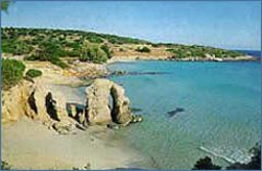
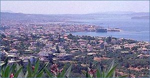
Lasithi Prefecture
|
The prefecture
of Lassithi covers the eastern end of the island. The
mountain range in this area is the Dikte. Its tallest
peak is Mount Dikte, 2,148 metres above sea level. The
prefecture has four provinces: Mirabelo, Lassithi, Ierapetra,
and Sitia. The major cities are Agios Nikolaos, Ierapetra,
and Sitia. The earliest settlements in Crete are in
this prefecture, including the palaces of Zakros, Praisos,
Mochlos, Vassiliki, and Gournia. An important early
Greek city, Lato, is near Kritsa. The fine Archaeological
Museums of Agios Nikolaos and Sitia display some of
the artefacts from these and other excavations. According
to legend, the Dikteon Andron Cave, on the Lassithi
Plateau, was the birthplace of Zeus. The area around
Agios Nikolaos is not only the most developed area for
tourism but one of the most interesting. The church
of the Panagia Kera near Kritsacontains some of the
best-preserved Byzantine frescoes in Crete.
|
|
Elounda has one of the strongest Venetian forts built
on Crete. The area of Sitia is full of Byzantine churches
and Venetian villas, as well as ancient Minoan sites.
The famous Toplou Monastery has a museum displaying
its well-known icon collection. The area also has
very good beaches with many coves between Ierapetra
and the Kapsa Monastery that offer excellent swimming.
The area of Vai has a unique palm grove that attracts
many people.
Ierapetra is one of the four provinces of Lassithi.
Its capital is the city of Ierapetra. The province
of Ierapetra has many good examples of Byzantine churches
with frescoes in them There are two monasteries of
note, Exakousti Monastery and Faneromeni Monastery.
East of Ierapetra there are many fine beaches in the
Makrigialos Bay.
Sitia is the largest province of Lassithi in area
and population. Its capital is the city of Sitia.
The mountains are lower then in other parts of the
island, but have a distinctive and varied landscape.
The earliest Minoan settlements are here at Mochlos,
Palaikastro, and the Minoan palace of Zakros. The
Kilada ton Nekron (Valley of the Dead) in Zakros and
the Hellenistic site of Itanos near Vai are also of
interest.
|
|
History
The Minoans ruled not only Crete
but other Aegean Islands and various cities on the mainland.
The great palaces that we see today at Knossos, Festos,
Malia and Zakros were constructed during this period.
Arts and crafts also reached their pinnacle also during
this "Golden Age". At this time, the great Minoan fleet
ruled the Mediterranean, providing wealth to the island
from trade and commerce as well as providing protection
from invaders.
|
|
A new disaster hit Crete around 1450 B.C., causing large-scale
destruction to the palaces and settlements and resulting
in the total demise of the great civilization. The next
wave of settlers, the Dorian Greeks, destroyed Mycenae
on the mainland and invaded Crete about 1100 B.C. They
established an aristocratic form of rule. Crete was
a strategic point in the eastern Mediterranean and one
that the Roman Empire needed. Crete fell to the Romans
and was a Roman province until 369 A.D.
The first period of Byzantine rule lasted from 395 A.D.
until 824 A.D. During this period Crete was part of
the Byzantine Empire, which had its capital in Constantinople.
After the final fall of Constantinople in 1453, Byzantine
scholars took refuge in Crete. Thus, the island became
a centre for Byzantine arts. During this time the renowned
icon painter Damaskinos studied with Dominikos Theotokopoulos,
"El Greco", at the school of Agia Ekaterini in Iraklion.
|
|
 |
By 1648, the Ottoman Empire
was in control of Crete, except for Iraklion
where the siege lasted twenty-one years. The
Greek War of Independence began in 1821 and
Cretan participation was extensive. The "Great
Cretan Revolution" began in 1866 and the
rebels scored a series of victories. Finally,
after years of struggle, the Great Powers (Britain,
France, Italy and Russia) decided that Turkey
could no longer maintain control and intervened
with the expulsion of Turkish forces in 1898
which led to the formation of the independent
Cretan Republic. Finally, in 1913, union with
Greece was realised under the Treaty of London.
|
In April of 1941, Nazi Germany began its attack against mainland Greece, rapidly penetrated the Greek defences, and occupied the country. At the end of World War II, Crete began reconstruction while the rest of the country was embroiled in a civil war. Due to this period of peace and also due to its favourable climate, the island became one of the most prosperous areas of Greece with agricultural products becoming a mainstay of Cretan economy
|
|
|
|
Today, tourism provides another economic boost to the island. Infrastructure built in the last twenty years accommodates this latest influx of foreigners. The superb climate and diverse beauty of the island beckon to visitors from all over Europe. |
|
|
|